
Elevation Certificate -Are You At Risk of Flooding?
“Thanks Keith – this [elevation certificate] helped [our client] a lot – quote went down to $460 – down from $2599.”
– Staci H., State Farm Insurance
If you need to determine if your house is located in a flood hazard zone, please call our surveyors at (979) 314-3131 or go to our Contact page and fill out the form there. We will promptly return your call to discuss your elevation certificate needs.
Flood Insurance Rate Maps
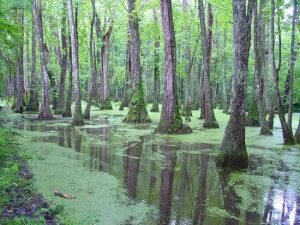 As you know, living along the Brazos River, you need to be aware of the FEMA Flood Insurance Rate Maps (FIRMs). These maps show the areas of potential flooding based on the 1-percent chance storm event.
This has been known in the past as the 100 year flood and is also known as the Special Flood Hazard Area (SFHA). When you get the amount of rain comprising the 1-percent storm the flood water will come to a certain elevation near your home, known as the Base Flood Elevation (BFE). The Flood Insurance Rate Maps for Bryan and Brazos County were updated in 2014.
Flood insurance rates are generally less the higher above the base flood elevation your finished floor is located. Therefore, if you are four feet above the BFE the rates should be lower than if you were at or below the BFE.
A $400 policy may well be worth the peace of mind it brings. Your homeowner policy has an exclusion from any flood damage. You should also know that just because you’re above the BFE and far away from a running stream, many dry ditches have caused significant damage to a home during a flash flood.
“purchasing flood insurance is mandatory…if the loan is federally insured or the lender is regulated by the federal government”
As stated above, your mortgage company may be required to ask you to purchase flood insurance. Of course, they would want you to do so because they are protected also. You should also know that the mortgage lender may also require flood insurance even if it is determined you don’t need it.
Flood insurance is highly advisable even if you’re not required to purchase but are located near a stream or lake. Remember, the 1-percent chance storm has a 1 percent chance of being met OR EXCEEDED in any year. Over the life of a 30 year mortgage there is a 26% chance of having a flood event that exceeds the base flood elevation. Now that you know a little about the overall situation, how does this affect you directly?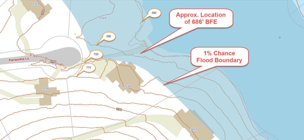
Are You In or Out of the Flood Hazard Zone?
If you are currently shown to be in or near a flood hazard zone, or if you’re going to be in or near a flood hazard on the proposed maps, NOW is the time to act. The following are the possible situations in which you may find yourself:
- OUT of the flood hazard zone completely on the old and new flood maps. This is great. In this case there is no requirement for the purchase of flood insurance. But, as we said below, if there is ANY risk you might want to consider it. An evaluation of your risk is quick and easy.
- You’re lot is currently shown in a special flood hazard zone on the flood maps. This puts you under the requirement for flood insurance. Your situation may now be one of the following:
- 2a. Your lot is “IN” the flood hazard zone but the lowest adjacent grade (LAG) around your house is “OUT” or above the base flood elevation (BFE). In this situation, it is possible that the flood insurance requirement may be removed. This process is called a Letter of Map Amendment (LOMA).
- 2b. Your lowest adjacent grade (LAG) is below the BFE but the lowest finished floor elevation (FFE) is above the BFE. In this case you need to purchase flood insurance. An Elevation Certificate is necessary as a way to determine your premium rate.
- 2c. Your lowest finished floor elevation (FFE) is below the BFE. This case is similar to 2.b. above but the flood risk is higher. Again, get an elevation certificate to determine your premium rate.
An Elevation Certificate is the First Step
If you’re in situation 2 above, the first step is to get an elevation certificate completed, also called flood survey by land surveyors.
The land surveyor will measure the elevation of your lowest floor elevation and the lowest adjacent grade to determine and then produce an Elevation Certificate that can be used to either complete the LOMA process or allow your insurance agent to get the flood insurance premium rate.
To talk about your elevation survey or elevation certificate, please call (979) 314-3131 or fill out our contact form to the right.
![]()
Definition of Keywords
FEMA – The Federal Emergency Management Agency – fema.gov – Fema’s mission is to “reduce the loss of life and property and protect the Nation from all hazards, including natural disasters…” One of the ways that FEMA “protects” us and helps to “reduce the loss of life and property” is through the National Flood Insurance Program (NFIP). To establish the insurance rates for each particular home, FEMA produces Flood Insurance Rate Maps (FIRMs). These maps identify the Special Flood Hazard Area (SFHA)
Flood Insurance Rate Map (FIRM) – The official map of a community on which FEMA has delineated the special hazard areas.
1-percent chance storm event – also known as the 100 year flood, the base flood and the Special Flood Hazard Area (SFHA) – the flood that has a one-percent chance of being equaled or exceeded on the average in any given year.
Base Flood Elevation (BFE) – The computed elevation to which floodwater is anticipated to rise during the base flood event. Base Flood Elevations (BFEs) are shown on Flood Insurance Rate Maps (FIRMs) and on the flood profiles.
Finished Floor or Lowest Floor – The lowest floor of the lowest enclosed area (including basement). Communities are required to obtain the elevation of the lowest floor (including basement) of all new and substantially improved structures.
Elevation Certificate – a form developed by FEMA that shows the elevations of buildings.. This form is also used by the property owner to obtain flood insurance.
Letter of Map Amendment (LOMA) – an official amendment, by letter, to an effective flood map. LOMAs are usually issued because a property has been inadvertently mapped as being in the floodplain, but is actually on natural high ground above the base flood elevation.